Hurricane Tracker: Helene's Path and Potential Impact on Florida

Hurricane Tracker: Helene's Path Towards Florida
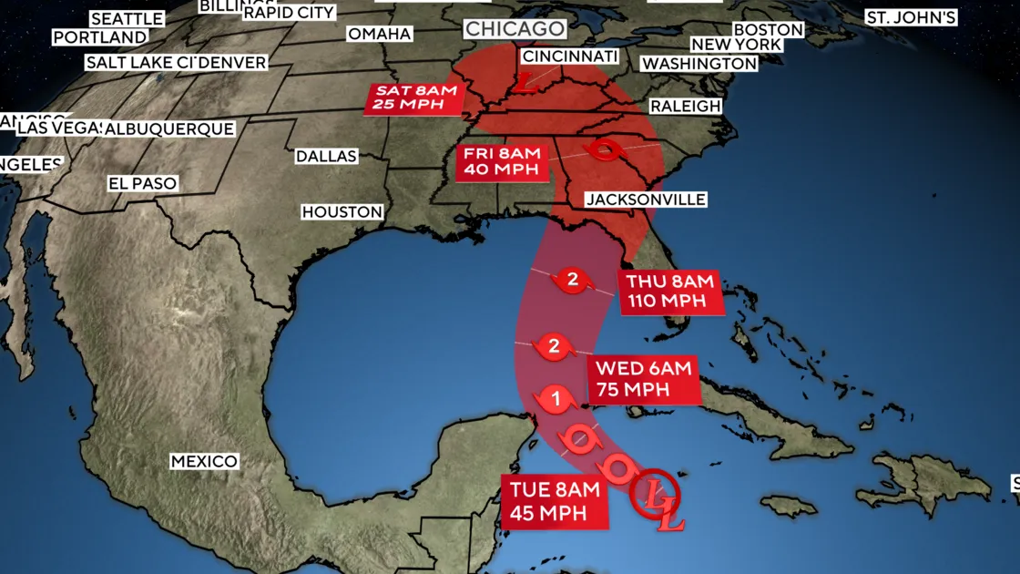
The Gulf Coast is bracing for the potential of a significant hurricane landfall just three days from now, as Hurricane Helene strengthens in the Caribbean Sea. The National Hurricane Center has classified a tropical disturbance southwest of the Cayman Islands as Potential Tropical Cyclone #9. Though the storm is currently disorganized, forecasts predict it will rapidly develop into Tropical Storm Helene on Tuesday.
Factors Contributing to Helene's Intensification
- Record-warm waters: Ocean heat content in the Gulf of Mexico is at an all-time high.
- Warm sea temperatures: With readings around 89°F, these waters are ideally situated to fuel Helene's growth.
- Influence of climate change: Current conditions have been exacerbated by human-caused climate influences.
As Helene approaches, travel plans to areas like Cancun may need reconsideration due to warnings in effect across western Cuba and the Yucatan Peninsula. By Wednesday, Helene might track over exceptionally warm waters, leading to accelerated intensification.
Projected Impacts of Hurricane Helene
- Rapid Intensification: Helene could gain up to 80 mph winds by Thursday, possibly becoming a major Category 2 hurricane.
- Destructive storm surge flooding: Communities along the Gulf Coast, from the Keys to Tampa, should prepare for potential flooding.
- Emergency Measures: Governor Ron DeSantis declared a state of emergency across 41 counties to facilitate preparations.
Residents are advised to remain vigilant as Hurricane Helene approaches, keeping in mind the unpredictable nature of storm tracks and the large area of impact associated with such systems.
This article was prepared using information from open sources in accordance with the principles of Ethical Policy. The editorial team is not responsible for absolute accuracy, as it relies on data from the sources referenced.